
European Space Agency’s orbiter captures ‘Dust Devils’ on Mars
Updated: Jun 19th, 2026
 |
| Image: European Space Agency (ESA) |
The European Space Agency’s (ESA) orbiter Mars Express has captured part of an area in Mars named Mamers Valley where a fascinating valley system speckled with brief, tornado-like whirlwinds known as ‘Dust Devils’ was found, as per ESA.
The images were captured using the High Resolution Stereo Camera (HRSC) aboard Mars Express, which has been studying and mapping the Martian surface since its launch in 2003.
Mars Express orbiter has captured images of a giant dust devil moving across the surface of Mars. These dust devils are formed when parts of the Martian surface heat up due to sunlight, causing warm air to rise and swirl while carrying dust particles with it, according to the ESA.
ESA said that Martian dust devils are similar to those found in dry and dusty regions on Earth, but they are much larger in size. They can rise up to 8 kilometres high, travel several kilometres across the surface and reach speeds of up to 45 metres per second. These dust storms play an important role in transporting dust across the planet.
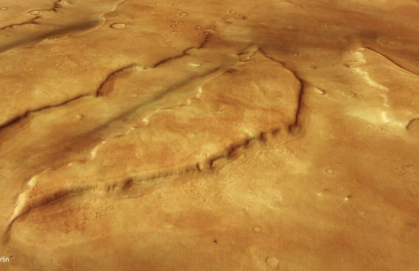
The images were captured over the Mamers Valles region, a vast network of canyons and valleys stretching nearly 1,000 kilometres across Mars. The area contains several unique geological features, including steep cliffs, flat-topped hills known as mesas and debris-covered glaciers containing buried water ice.
ESA explained that many formations in Mamers Valles are evidence of Mars’s ancient past, when water, lava and ice once flowed across the region and shaped its surface. Dark patches visible in some valleys are believed to be volcanic sands that were either formed locally or carried by Martian winds.
Dust devils form as parts of Mars warm in the Sun, causing the air just above the surface to swirl upwards and carry dust with it as it goes. Mars’s dust devils are similar to those we see in dry, dusty landscapes on Earth, but far larger; they tower up to eight kilometres high, rove about for kilometres at a time, and reach top speeds of 45 metres per second. They play a key role in moving dust across the planet.
Mamers Valles is a vast, broken-up, labyrinthine system of canyons and valleys etched into Mars’s surface. The feature was named in 1976 based on the ancient Oscan language of pre-Roman Italy, with ‘Mamers’ meaning ‘Mars’ and ‘Valles’ meaning ‘Valley’.
These channels stretch out for around 1000 km, crossing from Mars's ancient southern highlands into the planet's northern lowlands, and in places measure up to 25 km wide and 1.2 km deep (as shown most clearly in the associated topographical map below).
Surrounding these channels are various fascinating features: steep, flat hills known as mesas, sheer cliffs, and debris-covered glaciers. These glaciers contain water ice buried beneath a cover of rock and dust, and can be seen building up at the base of the steep slopes pictured here. All of these landforms come together to form fragmented or ‘fretted' terrain.
Patches of dark material can also be seen lining a couple of the valleys – likely volcanic sands that either formed in place or have been swept in by winds.
Many of the features seen here are signs of past activity related to water, lava, or ice, all of which once flowed across this terrain and carved out telltale marks as they did so.
Mamers Valles
Mars Express has visited this region of Mars before, imaging the areas surrounding both Mamers Valles (2008) and the neighbouring Deuteronilus Mensae (2019).
This image comes courtesy of the HRSC camera, one of eight instruments aboard Mars Express. Mars Express has been capturing and exploring Mars’s many landscapes since it launched in 2003. The orbiter has mapped the planet’s surface at unprecedented resolution, in colour, and in three dimensions for over two decades now, returning insights that have drastically changed our understanding of our planetary neighbou