How Deep Depression Is Brining Rain to Gujarat, What Districts Will Witness Heavy Rainfall

Summarized by AI; it may make mistakes. Check important info
Summarized by AI; it may make mistakes. Check important info

Gujarat is bracing for a fresh onslaught of intense monsoon activity as a potent weather system charges across central India towards the western coast.
According to the India Meteorological Department (IMD), a Deep Depression that originated over the Bay of Bengal has now established its core over west-central Chhattisgarh and the adjoining borders of Vidarbha and south-east Madhya Pradesh. The atmospheric engine is steadily moving west-northwestward, pulling an active monsoon trough southwards and triggering a coastal offshore trough that is drawing massive volumes of moisture from the Arabian Sea directly into Gujarat.
Administrators and disaster management teams across central and southern districts are on high alert as meteorologists project cumulative rainfall totals reaching up to 450 mm over the next 72 hours, threatening urban flooding and river overflows.
Trajectory and Movement: The Path of the Storm
The depression is currently centred over south-central Madhya Pradesh and adjoining north Maharashtra. Under its influence, heavy rainfall is likely to begin across several parts of Gujarat, including Ahmedabad, from late Friday afternoon.
The weather system is expected to gradually weaken into a well-marked low-pressure area as it moves westward and is forecast to enter Gujarat by Friday night.
Despite weakening, the system is expected to bring widespread rain, thunderstorms and gusty winds to many districts across the state.
Residents are advised to keep track of official weather updates and avoid unnecessary travel during periods of heavy rainfall.
Gujarat Landfall & Transit (July 31 – August 1): The storm center enters East and Central Gujarat. Torrential downpours will sweep across South Gujarat, the central industrial belt of Vadodara and Anand, and extend deep into the Saurashtra peninsula.
Coastal Exit (August 2–3): The circulation passes over Kutch and northern districts before emerging into the North-East Arabian Sea, where rainfall intensity will gradually begin to taper off.
Four-Day Breakdown: Where and When the Heavy Downpours Will Strike
Regional forecasting offices have outlined a four-day timeline detailing how rainfall will intensify and spread across the state:
Day 1: July 31 (Peak Red Alert Day)
As the heart of the system shifts directly overhead, Gujarat will encounter its most severe weather window. Extremely to exceptionally heavy rain is forecast across South Gujarat (Surat, Navsari, Valsad, Bharuch, Narmada), Central Gujarat (Vadodara, Anand, Kheda, Panchmahal, Dahod), and eastern Saurashtra (Bhavnagar, Amreli, Rajkot, Junagadh).
Rainfall begins in South Gujarat
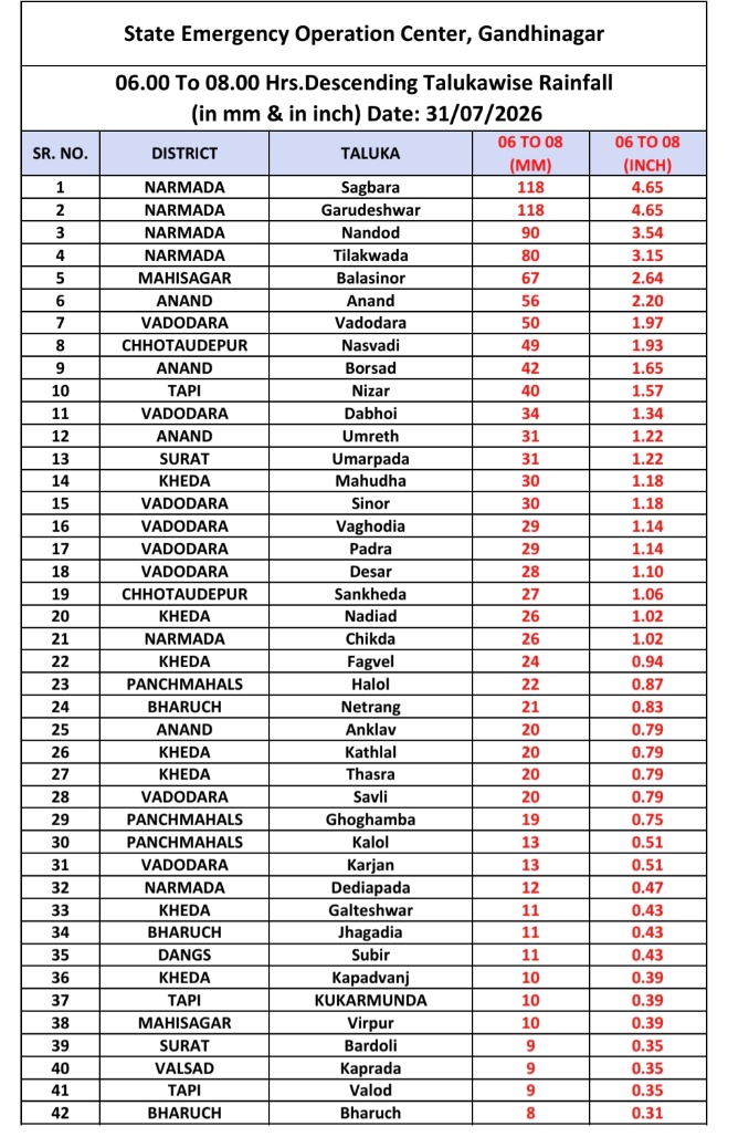
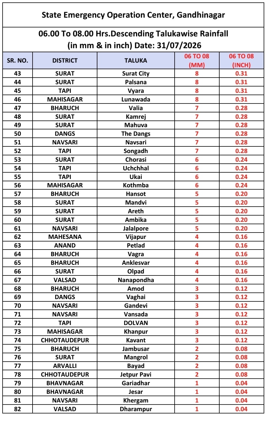
Day 2: August 1 (Widespread Heavy Rain)
Intense monsoon spells persist as the storm's core shifts towards North Gujarat and the western coastline. Widespread downpours will drench Banaskantha, Sabarkantha, Patan, Mehsana, Gandhinagar, and Ahmedabad, alongside Jamnagar, Morbi, Surendranagar, and Kutch.
Day 3: August 2 (System Tapering)
Peak spells begin to ease, though moderate to isolated heavy showers will remain active across Kutch, northern districts, and coastal Saurashtra.
Rainfall Impact and Flood Preparedness
The IMD has categorized expected precipitation depths to highlight potential civil hazards. Heavy rainfall (64.5 mm – 115.5 mm) is likely to trigger localized waterlogging on urban roads. Spells of Very Heavy Rain (115.6 mm – 204.4 mm) present risks of rapid river level rises and transportation delays.
During the peak period on July 31, isolated locations in South and Central Gujarat could record between 200 mm to over 300 mm within a single 24-hour window.
Extremely Heavy to Exceptionally Heavy rainfall exceeding 300 mm carries a significant threat of severe inundation, urban flooding, and river spillage along the Narmada, Tapi, and Vishwamitri catchments. Local civic authorities across affected municipal corridors have mobilized emergency response units and positioned rescue equipment in flood-prone zones.